onX Backcountry Snow/Trail GPS app by onXmaps, Inc.
 App Description :
Meet the ultimate GPS mapping app for your outdoor pursuits. onX Backcountry lets you easily find the trails you’re looking for—whether you’re seeking out new ski lines or trails to hike. Once you make a plan, bring it all out there with you by downloading an offline map to navigate when out of cell service.
App Features :
Discover New Adventures With Comprehensive Trail and Ski Line Information
Whether you’re looking to go for a ski tour, hike, run, mountain bike, or backpacking trip, we’ve got you covered. With over 650,000 miles of trails and 4,000+ ski routes, you’ll be able to discover trails near you.
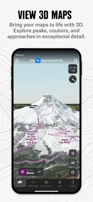
Prep Better For Your Outings With Powerful Planning Tools
We adventure in three dimensions, your planning should reflect that. With a 3D map you can visualize terrain, scout lines, and plan for hazards before you hit the trail. See recent conditions with reports from other trail users, and get winter snowpack info from SNOTEL stations and regional avalanche forecasts right in the app. Build custom routes seamlessly with snap-to-trail functionality, and drop Waypoints to leave notes on key points. Use Slope Angle, Slope Aspect, Trail Slope, and Wildfire Layers to plan in more granular detail.
Navigate Without Cell Coverage
Save Offline Maps to bring your custom maps and adventure along when you’re outside cell coverage on the trail. With the onX Backcountry App, you turn your phone into a handheld GPS device using your phone’s internal GPS. Navigate offline by following the blue dot to always know how to get home–wherever home is that night. Leave a breadcrumb trail with Tracker to see where you’ve been and measure your speed, distance, and elevation gain.
The Best Maps, Period.
With map data sourced from USFS, BLM, and NPS, our color-coded basemap helps you easily find what you’re looking for. Scout the landscape and visualize terrain by viewing your maps in 3D, topo, satellite imagery, or a hybrid. Elite users also get access to private landowner data and recent satellite imagery to go into the field even more informed.
PREMIUM AND ELITE BACKCOUNTRY APP FEATURES:
650,000+ miles of trails for running, hiking, backpacking, and mountain biking
4,000+ backcountry ski lines with guidebook descriptions from local experts
Avalanche forecasts for the U.S. and Canada
Recent snowfall information and historic trends via SNOTEL data
Snap-to route builder to plan trips and see distance and elevation gain in seconds
Save unlimited Offline Maps for offline navigation without cell service
Mark points along your route with photo Waypoints to plan and share your adventures.
Track your trips (location, speed, distance, and elevation) to know where you came from, how to get back, and share your adventure with friends.
Localized weather conditions and 7-day weather forecasts
24K topographic maps and 3D maps for the entire U.S.
Private Land Layer-ELITE ONLY: Nationwide private property maps and land boundaries, ownership information, and acreage
Recent Imagery-ELITE ONLY: Detailed satellite imagery from the past two weeks lets you see near real time conditions
985 million acres of Public Land across the U.S.
550,000 Recreation Icons for points of interest including:
Hiking and biking trail heads
Backcountry cabins and lookouts
Swimming and fishing access
Designated campgrounds, and dispersed camping areas
Free Trial
While the onX Backcountry App and many of its features are free, you’ll start a free Premium or Elite trial when you install the App. This allows you to try many of our best features, like 3D maps, unlimited offline downloads, trail data, and guidebook ski lines. After the first seven days, you’ll still have access to beautiful topographic and satellite maps, weather, and more.
FEEDBACK
If you have any trouble or have an idea on what you’d like to see in the app next, please contact us at support[at]onxmaps.com. We’d love to hear from you.
Additional Information :
- Age Rating 4+
- Size 379.5 MB
- Requires iOS 15.0 or later.
User Reviews :
Best Navigation App!!!
I purchased other nav apps before, and a few were decent, but there wasn’t one that pulled together all the features I love like this one! But the best part of onX Backcountry is the customer service. A couple weeks ago my iPhone battery was dying. The Apple store swapped it out. I backed up my phone, but, of course, none of the passwords back up. I was locked out of my accounts. I went to reset my password but my linked email account was locked and I couldn’t get in. I sent a help request to the onX Backcountry help desk and it was only minutes before they responded, changed my email to my back up account, and sent me a temp password. Start to finish…only a few minutes and I was rucking on! There are no other companies I deal with that have a response time like that! None! The sense of urgency is understood! If you’re debating purchasing this app, hesitate no more! Awesome features, emails with hints and tips to get max usage, and a top-notch help desk if anything goes wrong! Professional from start to finish. I know I’ll be renewing when the time comes because this is a company I can rely on! Run your own race. Hike your own hike. Live your own life. Backroads Buck
Developer Response,
Thank you so much for your support of both the Backcountry App and our customer service team. We really appreciate it and are so glad to hear that our team was able to get you back out on the trail!
Glad to hear you’re enjoying the App. It really is a game-changer for any time out in the field. Stay safe and have fun out there!
This app saved my toes!
Tried this out when backpacking Big Bend for the first time. Ended up getting snowed into a mountaintop campsite with a historic amount of snow. This app gave us the confidence we were going the right way to return to the base when we couldn’t see any trail or tracks at all and needed to get down in time to prevent frostbite.
The tracking works remarkably well and the UI is fairly intuitive. Also seeing the difficulty gradient along the trails is very useful for planning and decision making. My only suggestion would be to make it easier to access and view stats on previously tracked hikes. The only way I could find to access them was by tapping on the path on the map, but sometimes I had hiked the same segment many times making this an imprecise way to find precious data.
Developer Response,
Hi Ben, thank you for taking the time to share your support and feedback. We really appreciate it! We are so glad to hear that Backcountry helped to lead you safely back home. What a crazy situation!
I can definitely pass your feature request onto the team! We do have the “My Content” menu that would show each individual track once it is created. That may help you to sort out those previous trips.
Thanks again!
Get onX from App Store
What is your opinion about onX