Polaris app by Polaris Industries
 App Description :
Own your adventure with greater confidence and peace of mind, putting you in the driver seat with access to vehicle and riding details at your fingertips. Information you need when you need it to more easily tackle powersports ownership. Download now and plan your first trip!
App Features :
My Garage
View your vehicle service history
Stay on top of your maintenance schedules and receive reminders
Easily schedule your RideReady service appointments
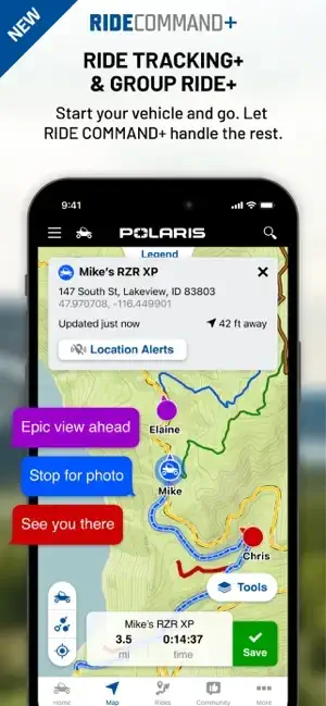
Rides & Community
Plan your ultimate ride using snap to trail routing and on/offline maps
Navigate during your ride with Group Ride, waypoints, and tracking
Relive and share your ride with 3D flyover of your tracked ride
Shopping & Support
Find your gear & accessories to elevate your ride
Easily get your questions answered at the Help Center
Unleash the full power by connecting to your in-vehicle display powered by RIDE COMMAND, or upgrade to RIDE COMMAND+ for next level remote vehicle connectivity and control.
RIDE COMMAND® is a registered trademark of Polaris Industries Inc.
Continued use of GPS running in the background can decrease battery life. Recommend running with power source.
Group Ride functionality requires cellular connectivity. If cellular signal is lost, RIDE COMMAND will show the last known location of riders in your group until signal is established again.
Additional Information :
- Age Rating 4+
- Size 228.6 MB
- Requires iOS 11.0 or later.
User reviews :
Can’t ride without it!
Great overall app. We’ve put over a thousand miles through this app, and I love the ability to see where we’ve been, even if it’s not tracking on a known trail or with a signal it tracks your path you’ve traveled. If we get lost, we can alway backtrack on our route. Only 2 things I would change: 1) When you press “stop” when tracking a ride, have it verify you want to stop. It’s a bumpy ride and I’ve gone to adjust my view of the ride and accidentally stopped tracking the ride. And once you do, there is no going back. 2) Be able to plan a ride and follow the trail like a car GPS does.
No offline map download option or it’s buggy
I used to love this app but can no longer download offline map regions. The only option is to ‘Choose Map Area’ and doing so just takes you to the map screen, allows you to zoom in or out on an area and take a screenshot they call a “map”. If you zoom in tight enough for trail numbers or FS road names then the screenshot is of a tiny area. Zoom out to capture the whole trail system and no labels. I haven’t tried but I assume this means when riding it’s not interactive either. There used to be a feature to select from a list of trail systems and download actual data for an interactive map. Considering that 90% of US Forest Service Area I ride in has no cell coverage this app is now useless.
This could be a bug but, if so, has been ongoing through several updates for months. Tried to provide bug feedback on app website and their form closed out in the middle of typing so, this is my feedback.
Developer Response,
It sounds like you may not be using the off-line maps feature correctly. Once you click on choose an area, the next screen is where you pick the area you want to download. This is just a geographical representation of how large of an area you want to download for offline use, like a snapshot. When you have zoomed in to the area you want, you then have to click the download button. Once you download an off-line map region, the app automatically populates the roads, trail data, waypoints, etc… on the normal map page. Clicking on the downloaded region in the off-line maps page just brings up the zoomed out image of the region, it does not bring you to the downloaded map. To test this out before you head out on a ride, you can go to the off-line map page and download a region you have not visited before. Once downloaded, close the app and turn on airplane mode to simulate no connectivity. Then open the app, and on the map tab, move the map to the area that you downloaded. You should see trails, roads and waypoints when you zoom in. Please note, with large off-line maps, it can take a minute for the map to load all of the downloaded map tiles. Please reach out to us at ridecommand-support(at)polaris.com if you still encounter issues.
Still works, was better
I have used this app for several years, it navigates most snowmobile trails in northern Wisconsin without issues. Like others, it was more useful, faster to respond, and less glitchy before the map vendor change. Please bring back those features, especially the feature of showing the direction the phone is pointed in on the map. Also, give the option to have map text in a larger font, it will help us with older eyes.
One quirk, “Show points of interest” keeps turning off when I close the app. All the others stay selected.
Thanks
Developer Response,
Thank you for the feedback. We are working on a fix for the “compass” feature and arrow pointing the correct direction which will be included in a future release. We will look at ways to increase the readability of roads/POIs on the map.
Get Polaris from App Store
What is your opinion about Polaris